
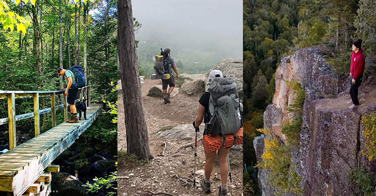
Hiking
North Country Trail in Wisconsin: Backtracking
 Seven years ago I began a quest to hike the North Country Trail across Wisconsin. Similar to my 20-year process of completing the Superior Hiking Trail in Minnesota, things are going slowly on the Sconnie side as well. In 2022 I completed just nine miles.
Despite my established reputation for tortoise-like hiking, I was determined to have a big year in 2023. Then I got busy with other things and ended up with exactly zero miles of NCT hiked that year.
I’ve already got one 2024 trek under my boots, but it kind of doesn’t count in terms of mileage. Which is why this chapter is titled “Backtracking.”
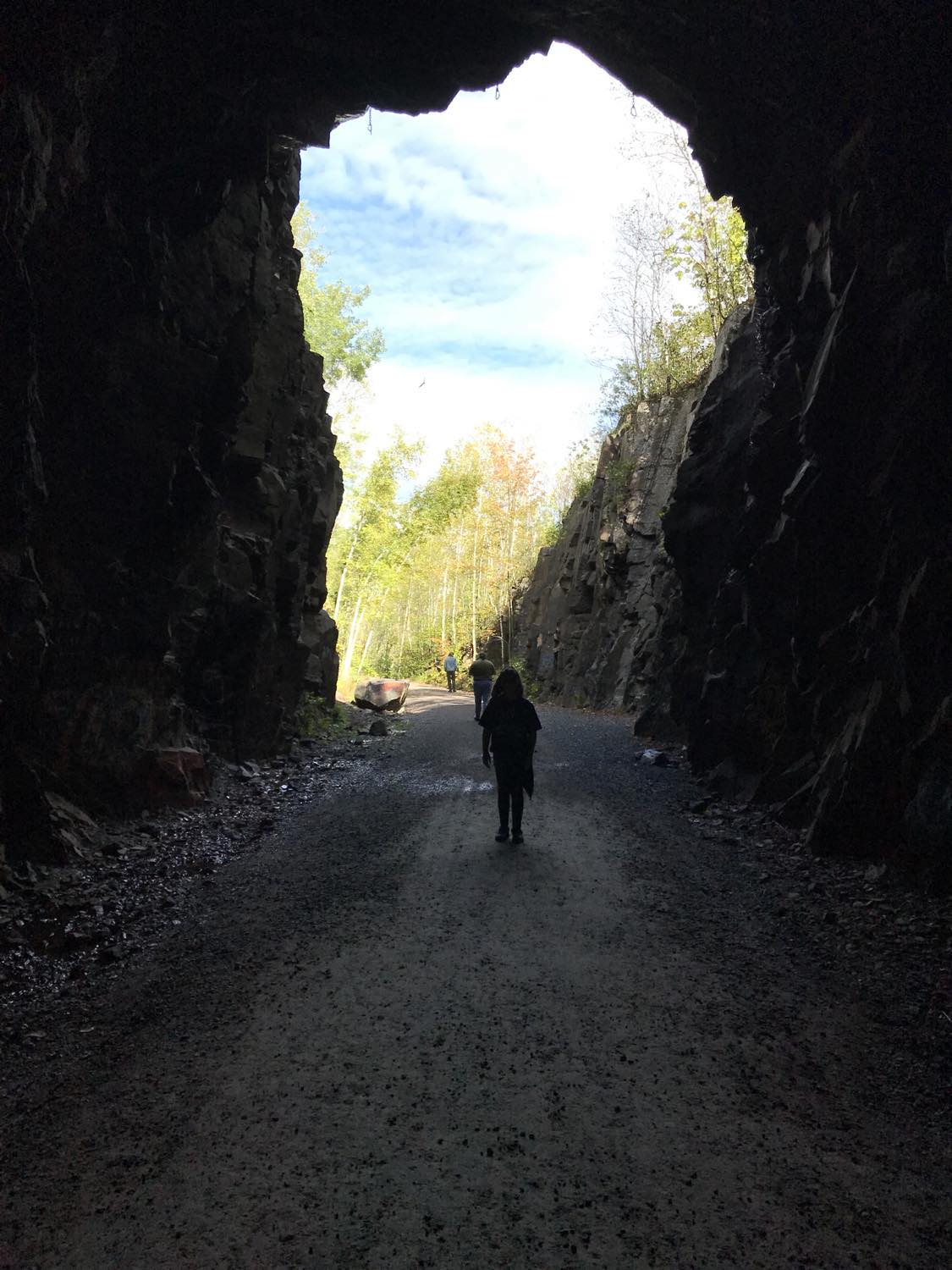
My only hike in 2022 began off Highway 53 on Holly Lucius Road, just south of Solon Springs. The previous chapter of my essay series concluded with a mistaken stroll on Highway 53, so I started my next hike by covering the path I should have taken at the end of my hike the year before. It wasn’t really backtracking, because I hadn’t walked this route yet, but it was a pause in my progression since it meant I would be arriving at Lucius Woods County Park for the second time. (more…)
PDD Quiz: Happy Trails to You
Lace up your boots and take a hike with this edition of the Perfect Duluth Day quiz, which highlights some local trails.
The next PDD quiz will review this month’s newsworthy events; it will be published on Sept. 24. Submit question suggestions to Alison Moffat at aklawite@d.umn.edu by Sept. 20. (more…)
Interpretive signs will mark former Incline Railway sidewalk
The Duluth News Tribune reports the sidewalk and stairway that marks the location of the former Incline Railway at Seventh Avenue West, designated as a recreational hiking trail, will soon have interpretive signage.
The Slice: Hiking Kadunce River in Winter
In winter the Kadunce River, an 8.5-mile stream near Grand Marais that flows into Lake Superior about 100 miles northeast of Duluth, becomes a frozen hiking trail.
In its series The Slice, PBS North presents short “slices of life” that capture the events and experiences that bring people together and speak to what it means to live up north.
Selective Focus: John Keefover
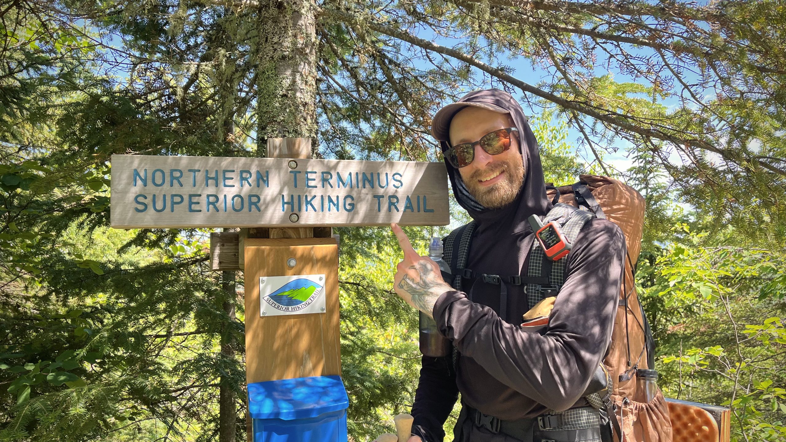
John Keefover poses with the Northern Terminus sign after completing his thru-hike of the Superior Hiking Trail.
John Keefover is the Duluth-based nature photographer behind the photography business Keefography. This June, Keefover thru-hiked the Superior Hiking Trail, sharing photos, videos and journal entries along the way. Keefover used this adventure as an opportunity to raise funds for the Wolf Ridge Environmental Learning Center. (more…)
North Country Trail in Wisconsin: Green Undies in Gordon
There generally isn’t a lot to say about a good hike, nice weather and beautiful scenery. They are enjoyable, but they don’t help create a classic story one tells his friends about and sits down to record in an essay. Good stories involve things not happening as planned. Something must go very wrong, very right or very strange to have a good story. If someone shows up in green underwear, for example, it at least provides the foundation.
So before I write about the numbers and geography of my hiking, let me assure you that green undies are coming up.
If you’ve been following along on my North Country Trail in Wisconsin series, you know I’m slowly hiking 214 miles across the Badger State. I started in 2017 and as of this writing have completed 65 miles, taking my sweet time.
In the summer of 2020 I hiked from Pattison Park to the edge of the town of Gordon and ended part four of my essay series there. I thought I was done for the year, but just a few days after publishing the essay I headed back to Gordon for one more trek. (more…)
Spirit Mountain, Mission Creek trail link ready
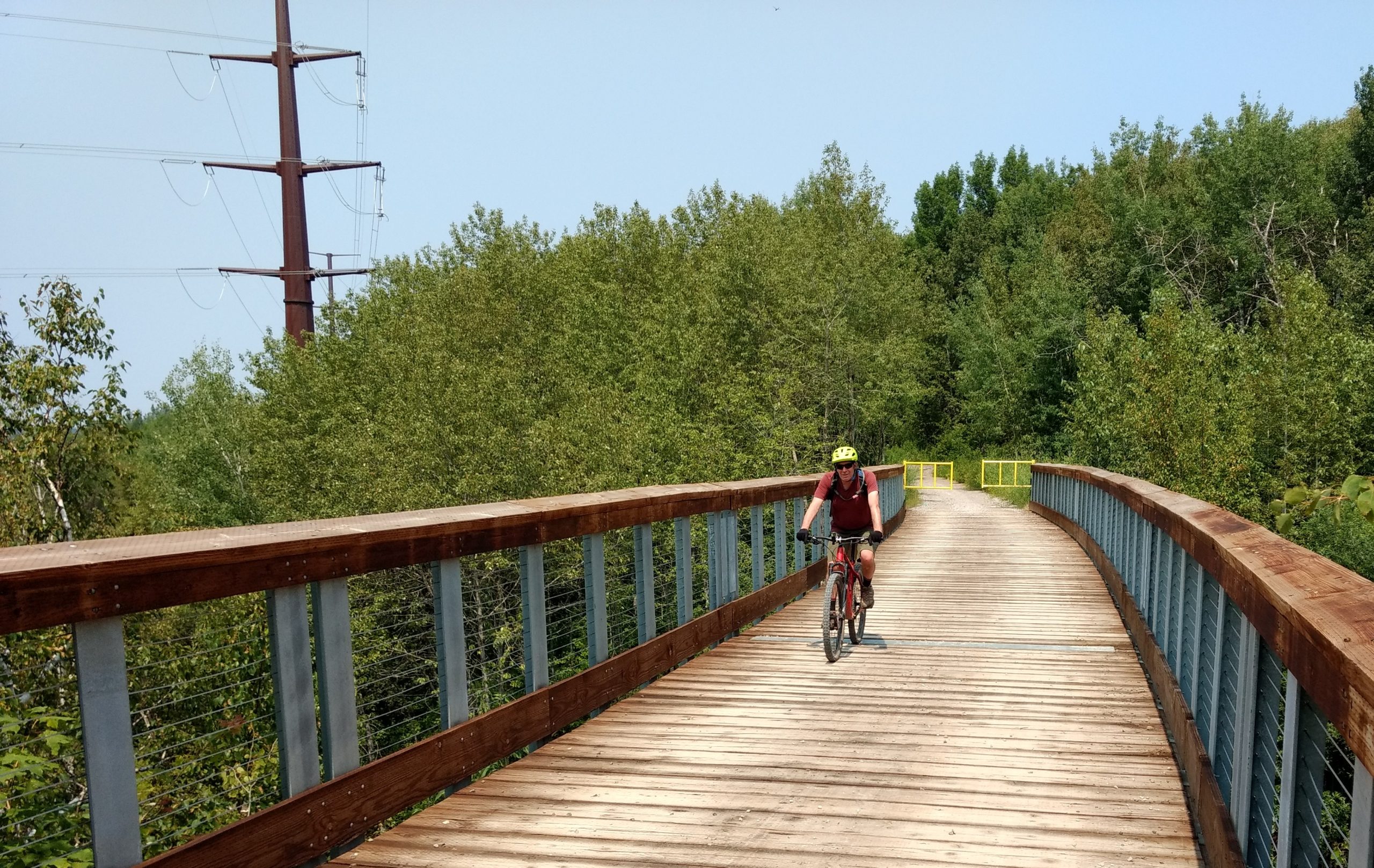
A biker crosses the new Sargent Creek bridge on the DWP Trail Connector west of Ely Peak. (Photos by Mark Nicklawske)
A critical bridge is open, a tunnel has been repaired and work is nearly complete on a six-mile scenic trail that uses a former rail line to connect two large recreation sites on the west side of Duluth.
The city’s Parks and Recreation Division is in the final stages of improvements to the Duluth Winnipeg & Pacific Trail Connector which provides a direct link between the Mission Creek trail system in the Frederick Rodney Paine Forest Preserve and Spirit Mountain. A ribbon cutting on the $600,000 trail project is expected later this summer. (more…)
Makwa Ziibiins Miikana: Bear Creek Trail to Wisconsin Point
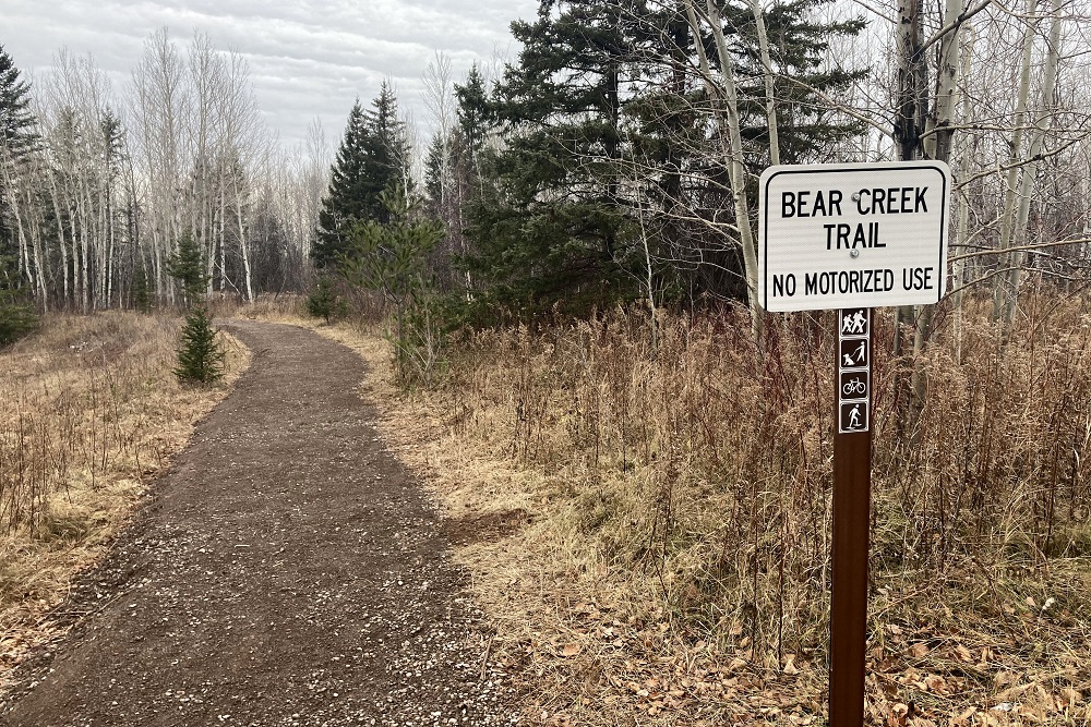
Last week Bear Creek Trail in Superior opened to hikers, bikers and snowshoers. It’s a 2.25-mile crushed-concrete pathway connecting the Osaugie Trail at Bear Creek Park to Wisconsin Point Road. An extension is in the planning stages that will create an additional trail on the other side of Wisconsin Point Road to parking lot #1. But what is already built is excellent. (more…)
Twenty Years on the Superior Hiking Trail: Ely’s Peak Loop
 The laziest and slowest record in endurance-sports history has been broken. Again. By me. Again.
As documented in numerous essays, I started hiking the Superior Hiking Trail on Sept. 23, 2000 and finished the 310-mile trek from the Canadian border to Jay Cooke State Park on Nov. 5, 2015. Obviously I took a lot of breaks along the way. Then, in 2016, I hiked new parts of the trail that hadn’t been built when I first went through, thus breaking the record I already held for the slowest unsustained complete traverse of the Superior Hiking Trail.
Was that an official record? Well, no organizational body really keeps track of such things. But I stand firmly in my declaration that no one who has hiked the entire Superior Hiking Trail has taken longer to do it than me.
And now I’ve taken even longer.
In the summer of 2018 a new loop trail was built at Ely’s Peak in Duluth. It was kind of late in the hiking season when I heard about it, so I planned to do it in 2019. Then I kind of forgot about it and got distracted with other things. I had also started a new quest to hike the North Country Trail through Wisconsin. I’m still barely started on that.
Anyway, this past July I drove out to the Ely’s Peak area with the intention of knocking out the new last bit of trail, but as I started walking it occurred to me that if I waited until Sept. 23 to do this loop my Superior Hiking Trail story would span a perfect 20 years. So I hiked other trials that day and saved the loop for the perfect day. (more…)
Selective Focus: Superior Hiking Trail
The fall tradition of folks of hitting the 310+ mile Superior Hiking Trail continues. Featured here are select photos from Instagram.
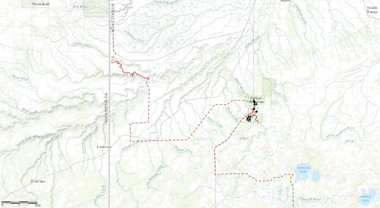
North Country Trail in Wisconsin: Town of Summit
One nice thing about hiking on county roads is that if a deer fly is pestering you and you happen to walk by a freshly killed skunk, the fly will transfer to the skunk and leave you to hike in peace.
There are also fewer ticks on roads than on trails, and you are less likely to get lost. But the benefits of a trail instead of a highway are obvious and substantial. In particular: the natural beauty of the land is a bit less interfered with on a trail, there are no motorized vehicles to watch out for, and on hot days there is usually some protection from the blistering sun.
Those are the basic pros and cons as I hike through the town of Summit in my quest to follow the North Country Trail through Wisconsin. As I’ve explained in previous essays, the trail isn’t built yet in the area near the Minnesota border, with the exception of the Nemadji River Valley, so there is a road route connecting sections of the trail.
Last summer I hiked county roads W and B to Pattison State Park. So far in 2020 I’ve hiked from Pattison to the border between the towns of Summit and Gordon. All of this has happened without any overnight camping or serious day of dedicated hiking. It’s just casual car trips to walk the road in there-and-back stretches. (more…)
Most natural surface trails in Duluth now open
Woohoo! The city has opened most of its natural surface trails. Now we all get to figure out the dance required to stay six feet apart when meeting someone on those narrow trails. (more…)
Muddy Trails and COVID-19: Duluth Hiking in Spring 2020
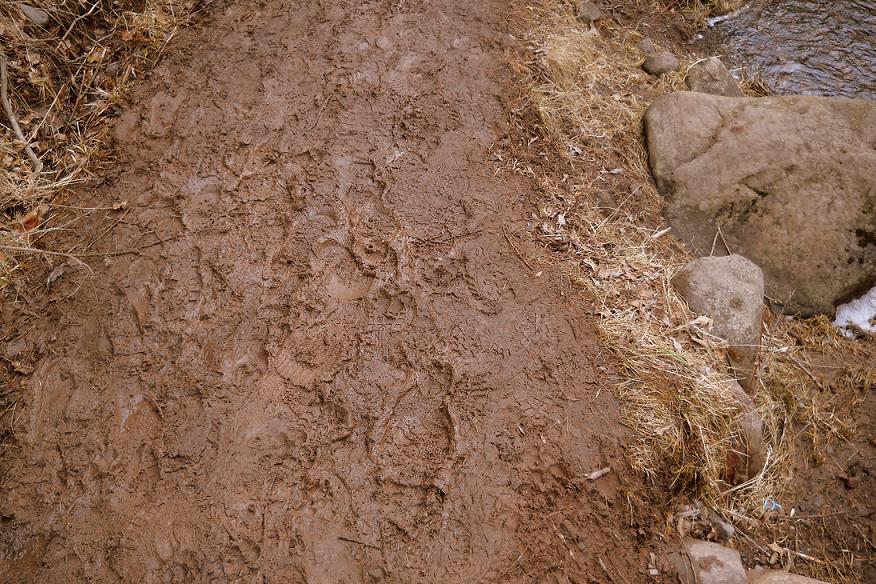
Duluth’s Parks and Recreation division has released guidelines advising citizens how to use city parks and trails in a manner that will reduce the transmission of the COVID-19 virus. March and April are also the months when snow is melting and natural-surface trails can be easily damaged.
So, where is it OK to hike and how is it done safely? (more…)
Duluth Adventures: An Encyclopedia of Human-powered Multisport Adventures
I’ve been a bit obsessed with planning human-powered multisport adventures in Northeastern Minnesota. Even within Duluth city limits, the options for loops are nearly endless. I was curious if anyone else out there had done similar trips in the past. Then I thought about how cool it would be to have a documentation of many routes for others to explore, want to replicate, or spur their creativity for a new route/loop. And Duluth Adventures was born!
Check out duluthadventures.com. This website pretty much hinges on other people’s submissions so I strongly encourage anyone to navigate to the “submit” button and send in their own routes.
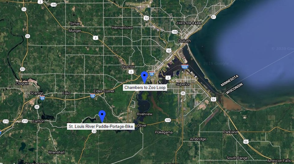
North Country Trail in Wisconsin: Crossing the Border
This is the third chapter in my quest to hike the North Country Trail across Wisconsin, but logistically it probably should be the first. As I’ve explained in previous chapters, the Superior Hiking Trail in Minnesota and the North Country Trail in Wisconsin aren’t properly connected yet at the border. The best thing a purist can do to fill the gap is hike on Minnesota State Highway 23 and a pair of county roads to get to a trailhead. So that’s what I did. Because I’m an annoying purist. Sort of.
It’s not so much that I’m determined to be annoying and pure. There are basically three reasons I wanted to hike on the roadways. 1) I know from experience that having a somewhat methodical goal inspires me to stay active. 2) If the pieces don’t all connect, it’s easy to lose track of where I’m at in the process, thereby thwarting reason #1. 3) Hiking on a trail in May is less fun anyway because of mud and ticks, so roads might be the best option anyway. (And if I were a true purist I’d strap on a backpack and hike across the whole state in a few days instead of breaking it up into numerous easy hikes.)
With all that in mind I parked my car on the side of Highway 23 near the Wild Valley Road sign and set out to connect my Superior Hiking Trail adventures to my fall 2018 North Country Trail hike at Nemadji River Valley. (more…)
Annual reminder: Stay off muddy trails in spring
Duluth’s Parks and Recreation Division has put forth its annual reminder that all natural-surface trails are closed until further notice due to wet soil conditions from the annual spring thaw.
So, where should people hike in April? (more…)
North Country Trail in Wisconsin: Nemadji River Valley
If you’ve ever hiked Minnesota’s Superior Hiking Trail to the Wisconsin border you know the trail ends there, but doesn’t really end there. Despite a sign on a tree that reads “Southern Terminus of SHT” and a separate post sticking out of the ground that reads “Not a trail,” there is clearly a trail there leading into Wisconsin. But it doesn’t go far.
The rest of the text on the terminus sign explains: “Spur trail from here to be built by North Country Trail to a parking lot in WI. Trail now dead-ends ahead.”
I explained all that 17 months ago in a Saturday Essay titled: “North Country Trail: Wood Tick Flats,” which was the first report on my quest to hike the North Country Trail across Wisconsin. That summer I covered exactly zero miles on the trail, which is not a great start to a 200-mile journey. If you read that first North Country Trail essay from June 2017 you know I didn’t hike on the trail that day because the grass was long and loaded with ticks. So I waited and saved the hike for a day with more favorable conditions … 17 months later.
What I lack in ambition I make up for with tenacity, right? My motto is: “Never quit. Take a nap and try again later when you feel more up to it.” (more…)
Superior Hiking Trail 100-mile Solo Trip
Fall is prime hiking season around Lake Superior. Linda O’Connell of Onalaska went on a 100-mile journey from the Canadian Border to Temperance River State Park in early September and put together this 37-minute documentary.
“Beautiful views, wrong turns and good food were experienced,” she writes in the YouTube description. “I am just an average American 50-year-old woman trying to get out of my comfort zone. Life is short. Make it count.”
North Country Trail Hike 100 Challenge … accepted
Linda O’Connell of Onalaska recently completed a North Country Trail Hike 100 Challenge. She went on four separate hikes from June to October, passing through Pictured Rocks, the Chequamegon National Forest, Brule River State Park Forest and Douglas County Forest, to reach a total of 100 miles.
“I had some struggles along the way,” she writes on the YouTube description. “I fell at Cheq & had blisters at Superior but I managed to achieve the 100 miles.”
Hiking Carlton Peak during fall colors
Video by Bill Thornton; music by Bill Frisell.
Portion of Chester Park Trail washed out
A segment of the hiking trail in Chester Park on the east side of the creek, between Skyline Parkway and the Eighth Street bridge, washed out during recent heavy rainfall. Trail closure signs are in place leading up to and around the area, along with orange fencing.
Duluth’s Parks and Recreation Division requests hikers avoid the washed-out area and instead use the trail on the west side of Chester Creek. The pedestrian bridge near Eighth Street is open for trail users to safely cross the creek to the west side.
North Country Trail in Wisconsin: Wood Tick Flats
You can’t start hiking the North Country Trail at the border of Minnesota and Wisconsin without first hiking in from one direction or the other. If you want to go southeast through Wisconsin, for example, you need to start on Wild Valley Road in Minnesota and hike in for 3.2 miles.
I don’t know how far into Wisconsin you’ll get if you try that. As of the date of this post, the interactive map on northcountrytrail.org is unclear. It’s hard to tell if the trail ends cold in the woods, dumps out on a highway or carries on uninterrupted.
On the gorgeous Sunday afternoon of June 4, I tried to solve this mystery and failed. It was still a fun scouting mission, though, and that’s what I’ll share in this essay. Obviously I could call the trail association or maybe spend an hour scrolling through Facebook posts to obtain the knowledge I seek about the state of the trail, but I’d still want to see it for myself, so why bother with the hands-off research, right?
It has been thoroughly documented in a series of 14 essays on this very website that I slowly and somewhat methodically hiked all of Minnesota’s Superior Hiking Trail in sporadic spurts from 2000 to 2016. That journey started at the Canadian border and ended on the Wisconsin border. But the trail doesn’t stop at either of those points. The SHT is part of a much longer trail — the North Country National Scenic Trail — which extends to Lake Sakakawea State Park in North Dakota to the west and Crown Point in New York to the east. (more…)
UMD Spring Break on the Appalachian Trail
Videographer David Cowardin tags along on a University of Minnesota Duluth Rec Sports’ spring break trip hiking a section of the Appalachian Trail in the state of Virginia.
Sixteen Years on the Superior Hiking Trail: Introduction
The yearning for adventure is a pretty common human trait, along with the practical good sense to not get into a situation you can’t handle. The old Scout Motto is “be prepared,” a creed intended to make one think practically and plan ahead for potential disaster. There’s a colorful expression for those who are not ready for life’s misfortunes; they find themselves “up Shit Creek without a paddle.”
Not wanting to drift helplessly in liquid feces, people often put off serious adventure and plan to check their dreams off a “Bucket List” at some point between the impractical now and the day before it becomes physically impossible. When a Bucket List goes as planned, it’s a beautiful thing. More often than not, of course, it ends up being a list of unfulfilled wishes. That’s generally preferable to premature death in pursuit of pretty scenery, so lament accordingly.
There are also those perfect people in the primes of their lives, dressing up in expensive wingsuits and gliding majestically down from the world’s most spectacular cliffs. Are they the sons and daughters of the obscenely wealthy or did they persuade a gear manufacturer to sponsor them? Maybe both. Don’t be jealous. You probably wouldn’t take that leap if you could. I know I wouldn’t. (more…)
North Country Trail nears connection to Superior Hiking Trail
A new 4-mile section of the North Country National Scenic Trail, located 17 miles southwest of Superior, opens Saturday, bringing the trail another step closer to connecting to Minnesota’s Superior Hiking Trail.
The new segment crosses the University of Wisconsin-Superior’s MacQuarrie Wetlands in western Douglas County and features scenic overlooks of the Nemadji River Valley and the basin of Glacial Lake Duluth. It also crosses a section of Douglas County Forest and Wisconsin DNR lands.