
Duluth Deep Dive #6: Superior Street in Six Acts

Superior Street around 1873. (Photo from the Northeast Minnesota Historical Collection)
The downtown section of Superior Street has a more complete photographic record than any other part of the city, revealing how dramatically Duluth’s main street has changed over time. This Duluth Deep Dive traces the 170-year history of downtown Superior Street by dividing its history into six periods and illustrating each period with a photo.
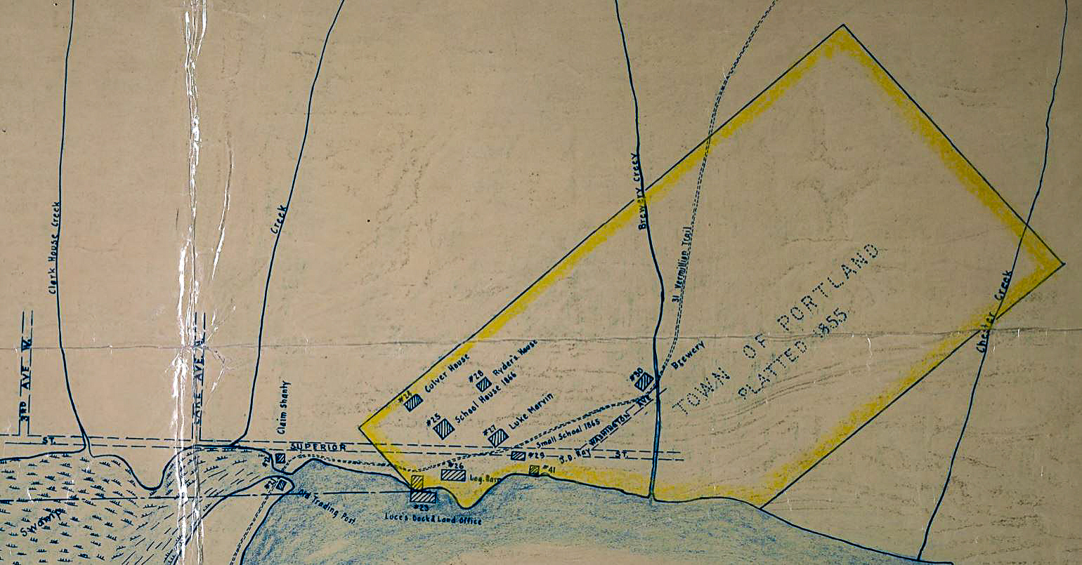
Section of a map of Duluth in 1865 made based on the recollections of R.E. Carey in 1931. (Image from the Duluth Public Library)
Superior Street is older than the city of Duluth itself. The Treaty of La Pointe in 1854 took away the control indigenous people had over who could live in the area, resulting in an influx of settlers. In 1855, Superior Street was platted as part of the Portland Township, a year before the establishment of Duluth Township just to the west. The early photos of Superior Street roughly correspond with the early years of photography itself. The collodion process, which allowed for multiple prints from the same negative, went into widespread use in 1851. The earliest images of northern Minnesota’s newly settled townships were taken with some of the earliest photographic techniques and technology. Superior Street was a popular subject for these early photographers, as it has continued to be throughout its history. This Deep Dive uses those photographs to show the transformation of Duluth’s central business district over the years.
1855 – 1893: Boardwalks and Boarding Houses
Superior Street in 1870. (Photo from the Northeast Minnesota Historical Collection)
The only thing that early photos of Superior Street have in common with the downtown that we know today is the location of the street itself. The sidewalks were made of elevated boardwalk to escape the mud of the street and the buildings were temporary wooden structures. As noted by Kathleen Murphy, the current buildings of downtown Duluth reflect every era of the city from the 1880s onward, but none of its earliest structures remain. This creates a challenge for aligning these early images with the street that we know today. The Clark House helps. The distinctive architecture of Duluth’s second hotel, seen at the end of the street in the photo above, marks the 100 block of West Superior Street. It was built in 1870 and destroyed by fire in 1881. The distinctive signboard of one of Duluth’s earliest newspapers, The Minneosotian, also often shows up in these early Superior Street photos (it can be seen on the far left in the lead photo of this post), but the office seems to have changed locations so often that it is of little use as a frame of reference. Their archives, now online and fully searchable, however, do provide a wealth of knowledge about the early days of Superior Street.
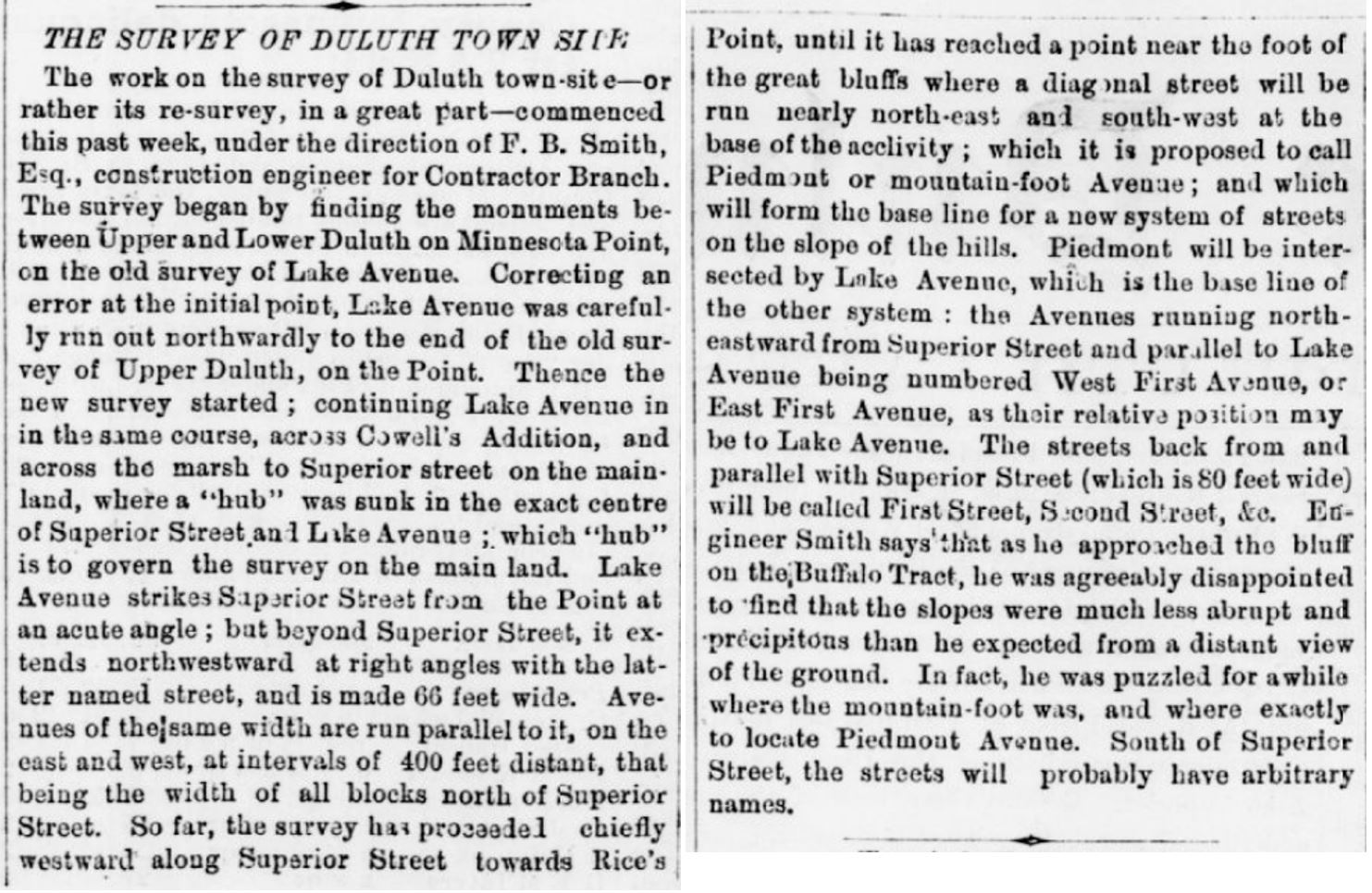
An article from the Duluth Minnesotian from May 15, 1869 describes how Superior Street will connect with the rest of the city. (Article from the Minnesota Digital Newspaper Hub of the Minnesota Historical Society)
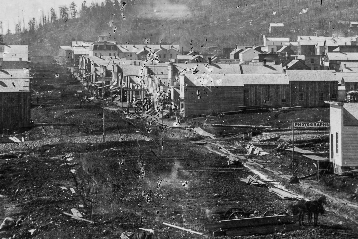
1893 – 1939 The Streetcar Days
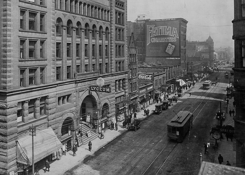
Superior Street around 1909. (Photo from the Northeast Minnesota Historical Collection)
The Superior Street shown in these photographs looks a bit more familiar. While the Lyceum may be long gone and while Fatima Cigarettes went out of business in the 1980s, Columbia Clothing remains a popular place to buy a suit on Superior Street. In this period, it is perhaps the street section itself that has seen the most dramatic change. From 1893 to 1939, the Duluth and Superior Streetcar systems connected the Twin Ports, with lines converging down Superior Street. At its peak in 1919, the system facilitated 45 million trips. Photos from this era show Superior Street at its busiest and most prosperous.
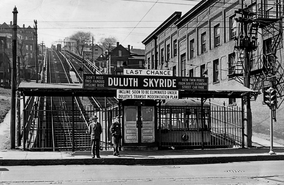
The Incline Railway on Seventh Avenue West in 1939. (Photo from the Northeast Minnesota Historical Collections)
The Incline Railway heading up Superior Street from Seventh Avenue West provides a clear orientation point for photos from this era. The Incline Railway had its last ride on Labor Day in 1939. The scattered segments of the staircase that once ran alongside it are its only remnants. According to Aaron Isaac’s book Twin Ports by Trolley, the extreme steepness of the incline railway route made the incline one of the last lines to be replaced by buses. If you want to ride a Duluth streetcar now, you have to go to Minneapolis, where the Minnesota Streetcar Museum still gives demonstration rides on Duluth Street Railway No. 265.
1939-1963: The War and Its Aftermath
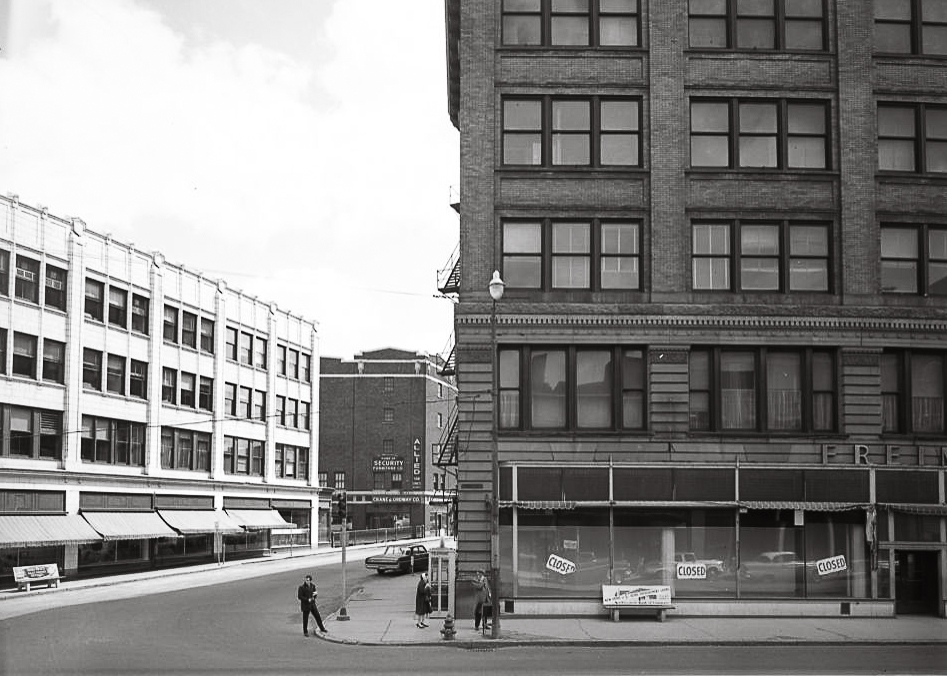
Superior Street in 1963. (Photo from the Northeast Minnesota Historical Collection)
The end of the streetcar area corresponded with another shift in the character of Superior Street. The photo above shows Freimuth’s Department Store, the oldest family owned business in Duluth when bankruptcy led to its closure on Oct. 18, 1961. It wasn’t just Freimuth’s that was facing challenges. A decline in iron ore production on the Iron Range had repercussions for the Duluth economy as well. At the beginning of this period, streetcars no longer brought people downtown. At the end of this period, the two passenger train stations on or adjacent to Superior Street, the Union Depot and the Soo Line Depot, both shut down. Many of the monumental buildings that formed the backbone of business and social life for the city began to fall into a state of disrepair. A photo series from 1963 systematically documented Superior Street in this period, anticipating another upcoming transformation.
1963- 1977: The Destruction of Renewal
Superior Street around 1975. (Photo from the Northeast Minnesota Historical Collection)
As described by Tony Dierckins in Duluth: An Urban Biography, in the post-war years, Superior Street between Fourth Avenue West and Mesaba Avenue became part of what the city referred to as the Bowery District. An area that had housed Duluth’s wealthiest tourists before the Great Depression and the war was now filled with semi-permanent residences for veterans, transient workers, and fixed-income retirees. The city decided to address this visible poverty by tearing down all of the housing options for low-income people on Superior Street as part of the Gateway Urban Renewal Project. Monumental historic buildings as well as less noteworthy structures around Fifth Avenue West were torn down. They were replaced by the buildings (and parking lots) that still anchor the west side of Superior Street today. The photo above shows Superior Street after the construction of the Radisson Hotel, Ordean Building and recently remodeled Gateway Tower, but before the construction of the new Duluth Public Library. The city also tore down other historic buildings on Superior Street during this period. In 1976, the Lyric Theater, a popular vaudeville house and later movie theater, was torn down for the construction of the Lyric Block Shopping Center, marking the start of Superior Street’s perhaps most dramatic transformation.
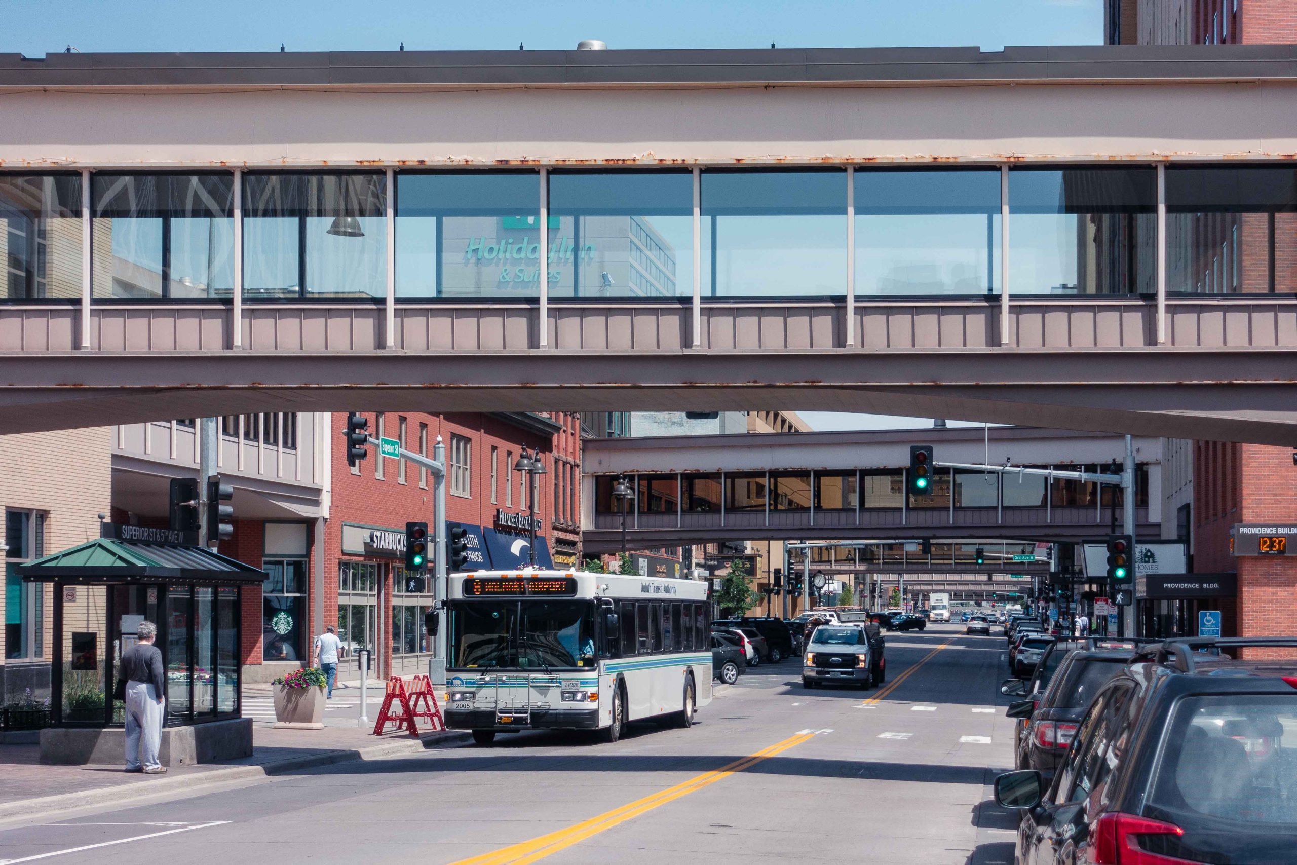
1977 – 2018: The Rise of the Skywalk
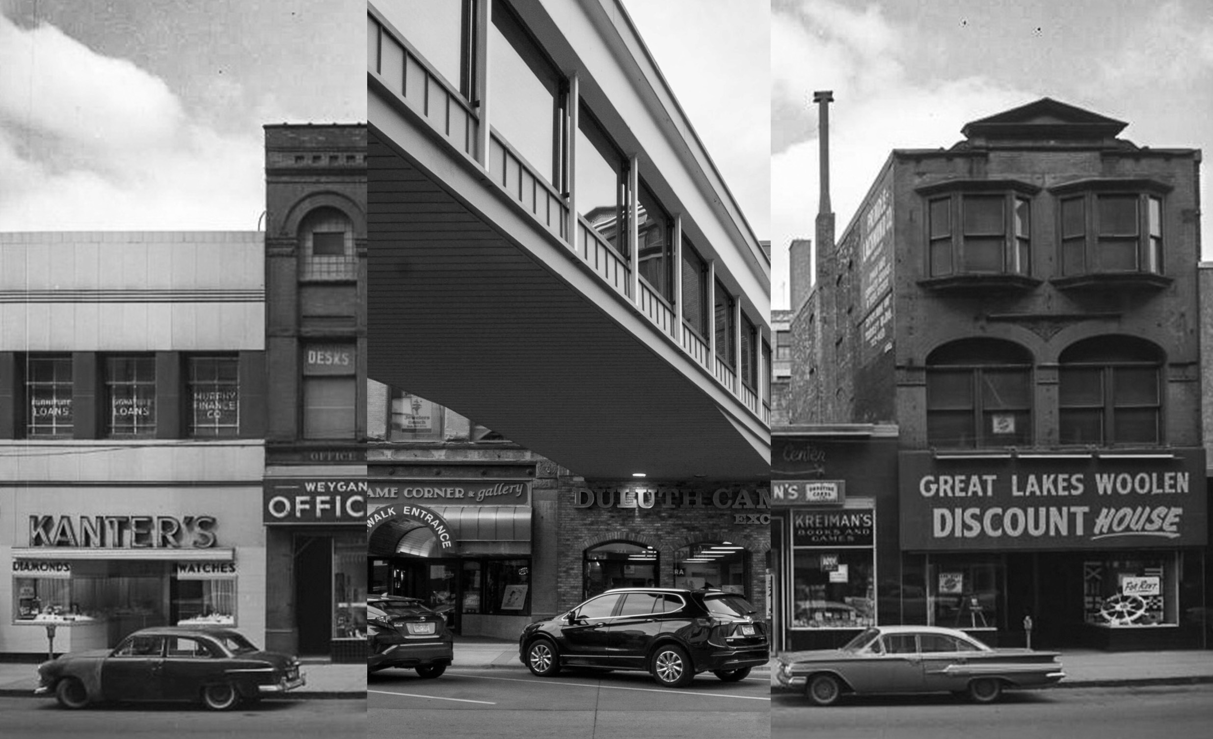
A composite photo of the 300 block of west Superior Street before and after the construction of a Skywalk connection. (1963 photo from the Northeast Minnesota Historical Collection/2023 Photo by Matthew James)
In 1978, an overhead walkway connecting the newly opened Normandy Inn (now the Holiday Inn) and First National Bank became the first segment of the modern downtown Skywalk System. When the Miller Hill Mall opened in 1973, it offered Duluth shoppers the ability to consume in a climate-controlled environment year round. Downtown could now promise the same. Undergoing multiple expansions both above and underground through 2008, the Duluth Skywalk may not have the grand lobbies of the world’s largest skyway system in Minneapolis, but it does provide a connected system of business and retail space that fundamentally transformed how people experienced downtown.
Enclosed pedestrian systems are a popular topic among academics because of how they alter the relationship between people and the city. When you enter the Skywalk system, you are on private property, which can be shut down, regulated, surveilled, and policed through entirely different processes than public space. The addition of the Skywalk system didn’t just allow downtown to compete with the safety and comfort that the mall promised, it transformed large segments of it into the controlled environment of the shopping mall.
The Skywalk and downtown mall weren’t the only elements of this transformation. In 1985, the city began a project to pave much of downtown, including Superior Street, with brick, creating a distinct look that set it apart from the rest of the city. Throughout the period of Skywalk development, the extension of I-35 through Duluth transformed the relationship between Superior Street, the lake, and the developing tourist center of Canal Park, connecting them in some ways and dividing them in others.
2018 – Present: Decentralization
Superior Street in 2022. (Photo by Matthew James)
It’s difficult to set a particular year when efforts shifted from keeping Superior Street as the heart of the city to ensuring it remains an economically viable part of the city. Certainly the closures and disruptions that came with COVID were harder on the businesses along Superior Street than other parts of the city. But this historical accounting chooses a starting point a couple of years before the pandemic, based on events beyond Superior Street. In 2018, two anchor stores closed at the Miller Hill Mall, Sears and Younkers. Sears had been in Duluth since 1929, moving to the mall after closing its store on Superior Street in 1983. In 1998, Younkers replaced Glass Block at the mall, whose Superior Street building was demolished in 1981. Superior Street had transformed itself to compete with the mall and the mall found itself struggling to compete with big box stores and online shopping.
The streetcar system once brought everyone together on Superior Street. The automobile, both in the form of personal vehicle and delivery vehicle, has made the downtown area pretty easy to avoid. Popular bars still stand along the length of downtown Superior Street but it doesn’t take much extra time to head over to Lincoln Park or even Superior, Wisconsin. Many want to shop locally on Superior Street but not as much as they want to park easily at Wal-Mart.
Which isn’t to say that Duluth is on an inevitable march to becoming a city without a heart. While storefront vacancies remain high, many non-retail businesses still operate on Superior Street. While you can no longer find a Maurices store downtown, it still has its headquarters there, the largest development project in the history of Duluth’s downtown. On the other side of the commercial center, the opening of the Essentia Building in 2022 gave Duluth a new tallest building, taking that honor away from the Alworth Building that had held it since 1910.
Even as the city debates how best to utilize an often empty Skywalk system, all of these new projects don’t just reflect new construction along Superior Street, but a potential return of workers looking for nearby housing, a quick lunch, a convenient grocery store, or a pleasant break-time walk. Which is all to suggest that a seventh act in the life of Superior Street may need to be added soon. What exactly that will look like remains to be seen.
This month’s Geoguessr challenge uses historical Google Streetview imagery to show some more recent changes to Superior Street. Because all of the locations are on Duluth’s most familiar street, this is a no move challenge.
Geoguessr Challenge: Superior Street Streetviews
More information on how to play Geoguessr can be found here.